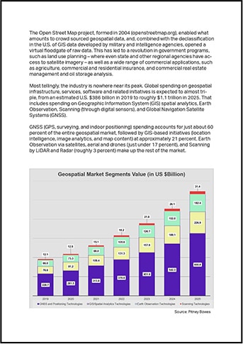
Starting in the early 2000s, a broad range of private sector industries and public sector regional and national government agencies had access to detailed imagery delivered through high-resolution imaging satellites, drones and aircraft. This has led to a geospatial revolution in government programs, such as land use planning as well as a wide range of commercial applications, such as agriculture, commercial and residential insurance, and commercial real estate management and oil storage analysis. Global spending on Geospatial infrastructure, services, software and related initiatives is expected to almost triple, from an estimated US $386 billion in 2019 to roughly $1.1 trillion in 2025.
Read the white paper to:
- Learn more the evolution of the use of geospatial data
- Understand the elements that are crucial in geospatial data derived from satellites, drones, and airplanes and how these vary by industry and use case
- Follow the key role semantic segmentation plays in geospatial data creation
- See how geospatial intelligence is being leveraged for private, and public sector use cases

First 300 words
The first flight into geospatial intelligence began on a brisk morning in November 1783 when Jean Frances Pilatre de Rozier – the world’s first Aeronaut – and a companion, the Marquis d’Arlandes, rose about 3,000 feet above Paris to gain an entirely new perspective on the City of Lights. With apologies to the 5th Century BC Babylonian scientists who developed civilization’s first rudimentary geospatial intelligence tools to map the city and monitor agriculture and other planning functions for the empire, de Rozier and the Marquis were the first humans we know of to gain a truly bird’s eye view of civilization in progress.
De Rozier’s flight lasted barely long enough to enable a few sketches, and the two aerial explorers were captive to the prevailing winds that eventually pulled their balloon to a landing in a field on the outskirts of the city. But the fledgling field of earth observation changed irrevocably that day, even if the two men had little to no idea of what was to come.
Fortunately, this field of knowledge, process and profession all rolled into one has progressed remarkably since then. Geospatial intelligence has become an essential tool for everything from national security, to land use and planning, agriculture, and a host of other commercial and government functions.
As with many broadly adopted commercial and consumer technologies, geospatial data services developed initially through military and government intelligence programs created to provide ground-level surveillance from an eye in the sky perspective. The 1962 Cuban Missile Crisis was grounded in an attempt by the Soviet Union to install nuclear missiles (and launchers) just off the coast of the United States – but the confrontation itself was triggered once surveillance photos taken by US military intelligence U-2 aircraft flying over Cuban territory had been thoroughly analyzed and…