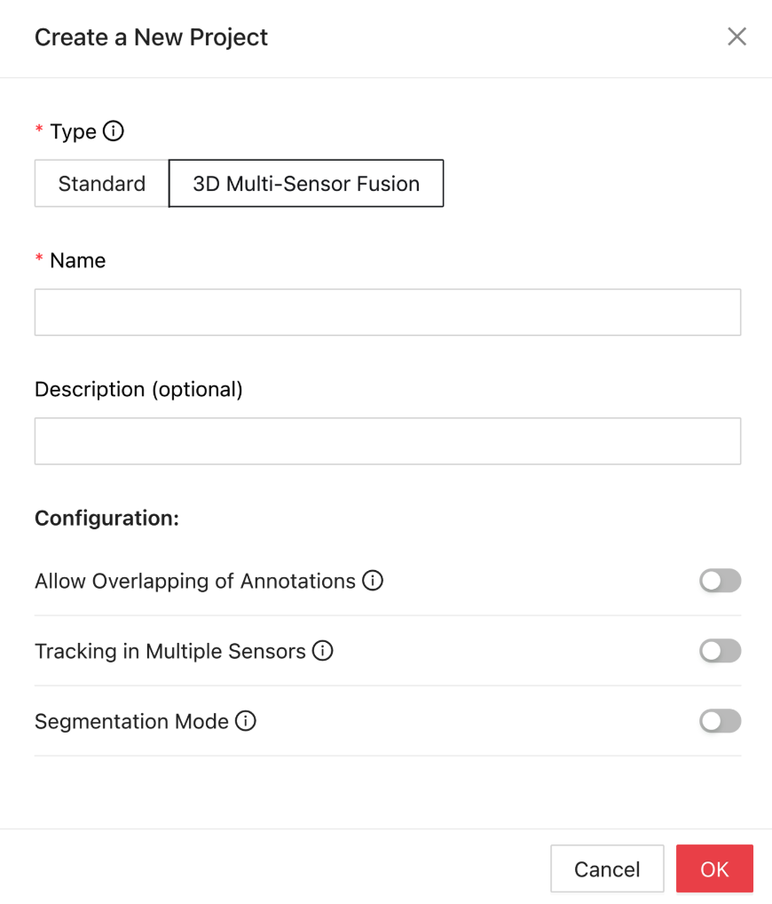
3D point cloud integration into Ango Hub streamlines the path to accurate multi-sensor fusion annotation. Users can easily create a new 3D Multi-Sensor Fusion (3DMSF) project right from the dashboard and configure settings based on project needs, defining category schemas, point cloud tools (PCT), and classification classes — all through a streamlined project setup experience.
Managing and uploading data is seamless. Teams can structure their 3D assets using cloud upload options and import them through efficient JSON configurations, enabling scalable bulk data handling with ease.
Once the data is uploaded, annotators can immediately begin labeling using Ango Hub’s intuitive Point Cloud Tool interface. This tool offers a user-friendly workspace and optimized task management, enabling teams to annotate, review, and submit tasks effortlessly, even across large datasets.
All project management happens through the Ango Hub portal at iMerit.ango.ai, offering easy navigation and control across every stage of the annotation process.
Watch the 3D Point Cloud Demo here:
Integrating 3D Data Seamlessly into Your Annotation Workflow
With Ango Hub, setting up a 3D Multi-Sensor Fusion (3DMSF) project is fast and flexible. Teams can easily configure category schemas, integrate Point Cloud Tools (PCT), and define classification classes tailored to their use case. Uploading and organizing 3D data is just as simple; users can manage large volumes of LiDAR and sensor data through structured cloud uploads and JSON-based configurations, making the platform ideal for complex, multi-sensor workflows.
Built for 3D Annotation and Beyond
Ango Hub enables teams to efficiently manage, upload, and annotate 3D files such as .pcd, .las, .laz, and .ply directly inside the platform. Whether working with single-frame files or zipped datasets, users can handle large volumes of 3D data seamlessly without needing external tools.
Users can configure project settings, add schema and classification structures, and organize 3D data alongside 2D images, videos, and sequence files — creating unified multi-modal projects ready for advanced AI training.
Key Features of Ango Hub Features for Multi-Sensor Fusion Annotation
1. Expert Talent via iMerit Scholars
Annotate point clouds using bounding boxes, polygons, polylines, and more, all designed for high-accuracy labeling in 3D space.
2. Multi-Sensor Fusion
Align 3D point cloud data with images, video, or other sensor inputs to create multi-modal datasets that mirror real-world environments.
3. Flexible Data Management
Upload and organize 3D data alongside 2D images, videos, and sequence files, making it easy to oversee complex, multi-modal annotation projects from a unified dashboard.
Why Multi-Sensor Fusion Matters
Modern AI applications, including autonomous vehicles, robotics, and smart city technologies, rely heavily on fusing insights from multiple sensor types. By integrating point cloud data with camera imagery or video, AI models gain a deeper, more accurate understanding of their surroundings.
3D sensor fusion, for instance, combines point cloud data with other sensor inputs to generate detailed 3D representations, enhancing the model’s ability to perceive depth and spatial relationships in the environment.
Precise multi-sensor fusion enables AI models to:
- Improve object detection and scene understanding
- Enhance distance and depth perception
- Strengthen decision-making processes in dynamic, real-world scenarios
By integrating point cloud data within multi-sensor workflows, Ango Hub ensures annotations are synchronized and aligned across modalities, creating consistent, high-quality datasets critical for AI development.
Scalable, Secure, and Built for Experts
Ango Hub’s 3D Multi-Sensor Fusion projects are designed for scalability, flexibility, and security. With configurable workflows, secure access control, and human-in-the-loop (HITL) quality review options, teams can confidently manage even the most complex annotation pipelines.
Did you know?
Even small misalignments between LiDAR and camera datasets can lead to major prediction errors in autonomous vehicles, making precise multi-sensor annotation crucial for safety.
Conclusion
Ango Hub provides a powerful environment for 3D point cloud annotation and multi-sensor fusion labeling, helping AI teams efficiently move from raw sensor data to production-ready datasets. With expert annotation, secure workflows, and a flexible platform, iMerit bridges the gap between complex 3D environments and real-world AI deployment needs.
iMerit’s experience in annotating datasets for autonomous mobility, including LiDAR, radar, and multi-camera fusion projects, ensures that clients receive high-quality labeled data ready for scalable AI innovation.
Learn more about annotating 3D point cloud files on Ango Hub here.